Phê Vé
April 6, 2026 • 4 min read
Route 66, often referred to as "The Mother Road," is famous for its neon signs, roadside diners, and vintage motels reminiscent of the 1950s. Designed for long road trips, this iconic highway winds through countless small towns, featuring gas stations, eateries serving homemade pies, and blinking mo
Discover the Wonders Along Route 66
Route 66, often referred to as "The Mother Road," is famous for its neon signs, roadside diners, and vintage motels reminiscent of the 1950s. Designed for long road trips, this iconic highway winds through countless small towns, featuring gas stations, eateries serving homemade pies, and blinking motel signs beckoning travelers to stop. However, this legendary route offers much more than just nostalgic charm; it also showcases stunning natural attractions along the way.
Stretching over 2,500 miles, Route 66 runs from the heart of America to the Pacific coast, passing through caves, canyons, lava fields, mountains, and deserts. Many of these breathtaking locations have now become national parks, state parks, or national forests. Several parks are just a short detour from the main highway, and some are conveniently located right next to it, allowing you to immerse yourself in nature with ease.
Must-See Stops Along Route 66
Here are nine unique parks you should add to your Route 66 adventure.
Walnut Canyon National Park (Arizona)
Distance from Route 66: 5 miles
Entrance Fee: $25 per vehicle (cash not accepted)
Address: 3 Walnut Canyon Road, Flagstaff, Arizona 86004
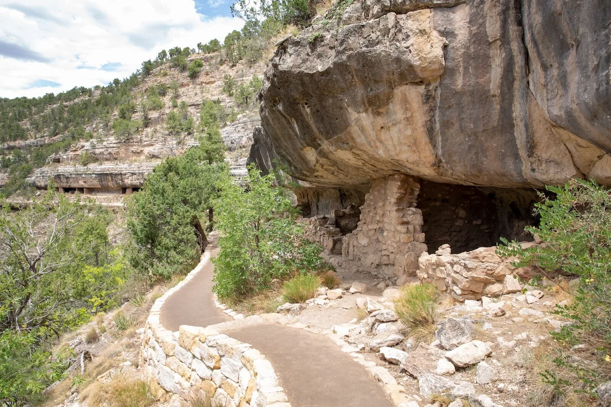
Just a few miles from Flagstaff, Walnut Canyon preserves a series of natural limestone caves that were once home to the Sinagua people from around 1100 to 1250 AD. These dwellings are built directly into the canyon walls and are still visible today. The main trail, Island Trail, is about a mile long and features steep inclines with stairways.
Along the way, you'll pass about 25 rooms, many just a few steps from the trail. Although the hike is short, it does require some stamina for the ups and downs, so plan for 1-2 hours and bring plenty of water. The trail closes at 4 PM daily, so make sure to time your visit accordingly.
Indiana Dunes National and State Park (Indiana)
Distance from Route 66: Approximately 30 miles
Entrance Fee: $25 per vehicle
Address: 1215 N State Road 49, Porter, IN 46304
✈️ Tìm chuyến bay giá tốt
Đặt vé ngay với giá ưu đãi từ các hãng hàng không
Indiana Dunes National Park hugs the southern shore of Lake Michigan, protecting around 15 miles of coastline with a mix of beaches, wetlands, forests, and the highest sand dunes in the Midwest. Here, you'll find numerous short trails that meander through diverse landscapes within a compact area.
Located just east of Chicago, it's a great stop before you hit the road on Route 66. The most popular stop is the Dune Succession Trail at West Beach, featuring a short climb that offers stunning views of Lake Michigan and the surrounding dunes. In the summer, the beaches here are open for swimming, making it one of the few Route 66 stops where you can actually take a dip!
Lava River Cave (Arizona)
Distance from Route 66: 14 miles
Entrance Fee: Free
Address: Forest Road 171B, Flagstaff, AZ (no official address)
Lava River Cave is a lava tube located in the Coconino National Forest in northern Arizona. It was formed approximately 700,000 years ago when lava flowed out but the inner lava continued to flow, creating a tunnel that stretches about three-quarters of a mile, making it the longest known lava tube in the state. The cave is open to the public, and anyone can enter without a guide or reservation (though some precautions are recommended).
Petroglyph National Monument (New Mexico)
Distance from Route 66: 8 miles
Entrance Fee: Free
Address: GPS Lat: 35.139 GPS Long: -106.711, Albuquerque, NM 87120
Petroglyph National Monument is one of the most unique historical parks along Route 66, featuring over 20,000 images carved into volcanic rock by Native Americans and Spanish settlers centuries ago. From the visitor center, you will need to drive a few minutes to one of three canyon trail areas: Boca Negra Canyon, Rinconada Canyon, or Piedras Marcadas Canyon.
Mojave National Preserve (California)
Distance from Route 66: Approximately 20 miles
Entrance Fee: Free
Address: 90942 Kelso Cima Rd, Essex, CA 92332
As Route 66 moves into California, it skirts the lower edge of one of the largest protected desert areas in the United States: Mojave National Preserve. This area protects 1.6 million acres of land featuring sand dunes, lava tubes, volcanic craters, and dense Joshua tree forests. The region is incredibly quiet and often deserted, with stretches of road where you might not see another soul for miles.
Onondaga Cave State Park (Missouri)
Distance from Route 66: 7 miles
Entrance Fee: Free, with fees for guided tours
Address: 7556 Highway H, Leasburg, MO 65535
Onondaga Cave State Park is located just south of Route 66 in central Missouri and is one of the easiest places along the route to take a cave tour. The park protects two large caves: Cathedral Cave and Onondaga Cave, the latter being a National Natural Landmark.
Phê Vé
Phê Vé is a leading online flight booking platform in Vietnam, providing accurate and up-to-date travel information. We are committed to delivering wonderful travel experiences with the best prices on the market.